

| Author: | Peter Campbell |
| Date of forest visit: | 14 – 16 April 2007 |
| Report issue date: | Wednesday, 5 September 2007 |
| Version: | Final, v1.0 |
Executive summary
This report assesses some of the forest areas in East Gippsland that were announced for protection during the 2006 Victorian State Election campaign. The purpose of this report is to assess the quality and quantity of some of the forest areas newly protected and surrounding forests with respect to the stated aims of the Government which were to protect under the National Parks Act the last significant stands of Victoria’s old growth forests (available for logging) to enhance tourism and protect biodiversity.
The three areas covered by this report are outside of the proposed new reserve system and are considered to be also all worthy of protection.
The Brown Mountain region bounded by Errinundra Road to the east, Legge Road to the east and Errinundra National Park to the south contains numerous very significant old growth Mountain Ash trees with a largely intact understory. This forest area is a firm candidate for protection due to biodiversity value and age of the forest. This area should be included in the new reserve system to improve its continuity and enhance the wildlife corridor. In addition, National Park signage in this area is in need of immediate attention.
The Jungle Creek catchment south of the Aberdeen Track contains significant old growth Mountain Ash trees, cool temperate rainforest plant species and wet sclerophyll forest. This area should also be included in the new reserve system to improve the continuity of the reserve and further enhance the wildlife corridor. It is imperative that fuel reduction burning of this area of forest includes measures to protect both old growth trees and the wet sclerophyll forest.
Heavily logged forests along both the Mount Jersey and Yalmy Roads and the Rodger River Track detract from the visual characteristics of this region due to loss of forest canopy and large amounts of logging residue. In addition, regrowth areas will have little appeal or habitat value for many decades. This has a major negative impact on tourism potential. Logging activities in these areas should cease – they should be added to the National Park estate.
Some significant forest areas of high quality along the Yalmy Road adjacent to the Snowy River National Park have been newly protected. However, other adjacent areas of equivalent forest have not been afforded any protection. This indicates apparent inconsistencies in the decision making process regarding the selection of areas for protection.
An impressive stand of old growth Mountain Ash with very high visual appeal is located on the Yalmy Road close to the intersection with the Rodger River track. Mountain Ash (Eucalyptus regnans) is comparatively unusual in East Gippsland. While sections of this forest have been logged, the overall impression is of majestic trees. The rationale for excluding this area from the new protected reserves is not clear. It should be also be added to the reserve system both to protect the remaining old growth trees it contains, and to boost and improve the integrity of the adjacent Snowy River National Park.
While additional areas of old growth forest have been specified for protection in East Gippsland, there are good opportunities to further add remaining unprotected old growth and wet sclerophyll forest to the reserve system for the intrinsic value of these forests, to create a more robust wildlife corridor link between the Errinundra and Snowy River National Parks and to protect resident endangered species.
Introduction
This report assesses some of the forest areas about to be protected that were announced during the 2006 Victorian State Election campaign. Material and photographs for this report were gathered during a visit to East Gippsland forests in the Goongerah region on 14 – 16 April 2007.
The purpose of this report is to assess the quality and quantity of some of the forest areas newly protected and surrounding forests.
Acknowledgement
I would like to thank Jill Redwood for her assistance and advice during my visit to East Gippsland to gather material for this report.
Background
During the 2006 Victorian State Election campaign, the Victorian Government made the following commitments relating to East Gippsland forests:
“Over the next 4 years a re-elected Bracks Government will:
Immediately protect the Goolengook Block and the last significant stands of Victoria’s old growth forests currently available for logging under the National Parks Act. In total this will add almost 33,500 hectares of forest to the National Parks and reserve system.
Create the Great Victorian Alpine National Park by adding a 5000 hectare section of State Forest currently available for logging to link the Errinundra National Park to the Snowy River and Alpine National Parks and pursue World Heritage Listing of a Great Alpine National Park in partnership with the ACT and NSW.
Immediately add 2,500 hectares of icon State Forest in East Gippsland currently available for logging to the National Parks and reserve system.”
Source: Victoria’s National Parks and Biodiversity, Policy for the 2006 Victorian Election (Bracks Government), 17/11/2006
Further details on this policy were provided in an accompanying fact sheet:
- The investigation by the Victorian Environment and Assessment Council (VEAC) into the Goolengook block would cease as the block will be permanently protected.
- In addition to the Goolengook Block remaining significant stands of old growth forest currently available for timber harvesting will be immediately protect by including them in the National Parks and reserves system.
- It doesn’t make sense from an environmental or commercial perspective to allow the few remaining large stands of old growth forests to be logged. In addition to their visual majesty, old growth forests are rich sources of biodiversity and habitat to a range of species.
- The benefits for tourism, and market access opportunities for the timber industry from protecting the remaining significant old growth timber stands, clearly outweigh the on going minimal returns from the harvesting of old growth forest.
Source: Labor protects last significant old growth stands, 17 November 2006.
See Appendix 3 for more details
The fact sheet also contained a map of proposed new parks and reserves in East Gippsland (see Appendix 4 for a larger version of this map).

My interest in visiting East Gippsland was to assess the quantity and quality of the new proposed parks and reserves.
I chose to visit three main areas that were either adjacent to outside of the proposed new reserve areas identified on this map.
Overall context

The areas I chose to visit and their regional location are depicted in Map 1.
- B refers to Legge Track forest area on Brown Mountain
- A refers to the Aberdeen Track area in the Jungle Creek catchment
- Y refers to Yalmy eucalypt forests and the Yalmy Road
These areas are shown in more detail in Map 2 below.

The three areas visited overlaid on the protected areas map provided by the government are illustrated in Map 3.

Each of these three areas are outside of the announced new proposed reserve areas and will be covered in more detail in the following sections, with photographs provided.
Brown Mountain region

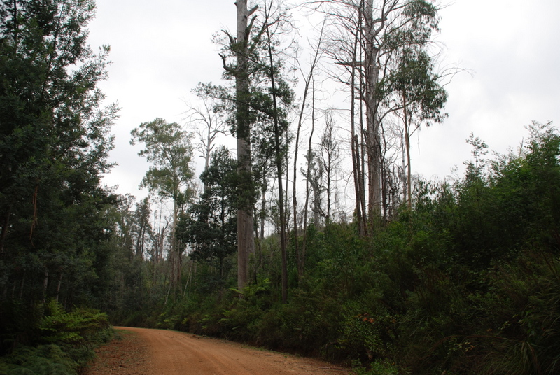
The Brown Mountain area visited was to the east of Legge Road just South of part of the Errinundra National Park. This area contains numerous very large old growth Mountain Ash trees with an intact understory. This forest area is a firm candidate for protection due to value and age of the forest, yet it has been omitted from the proposed new reserve area.
Summary and recommendations
The Brown Mountain region bounded by Errinundra Road to the east, Legge Road to the east and Errinundra National Park to the south contains numerous very significant old growth Mountain Ash trees with a largely intact understory.
This area should be included in the new reserve system to improve the continuity of the reserve and enhance the wildlife corridor.
Brown Mountain region


Aberdeen Track

The Aberdeen Track traverses a ridge above the Jungle Creek catchment to the north west of Goongerah. This area is outside the new reserve system announced.
A fuel reduction burn was scheduled and signed for Autumn 2007 season. I spoke with the Bendoc Department of Sustainability and Environment office and was informed that these burns were required as part of the fire management plan to protect local residents and to protect the ecological integrity of the forest.
I queried whether any management plans were in place to protect high conservation value parts of this forest area, specifically the cool temperate rainforest gullies the would suffer greatly from burning, and was informed that no special measures were to be taken in the regard.
Summary and recommendations
Areas of forest in the Jungle Creek catchment below the Aberdeen Track contain significant old growth Mountain Ash trees, cool temperate rainforest plant species and wet sclerophyll forest.
This area should be included in the new reserve system to improve the continuity of the reserve and enhance the wildlife corridor.
Fuel reduction burning of this area of forest should include measures to protect old growth trees and wet sclerophyll forest.
Aberdeen Track Photos


Yalmy Road and Mount Jersey Road
The Mount Jersey Road heads northeast through heavily logged forests to join the Yalmy Road. The Yalmy Road travels along the boundary of the Snowy River National Park (to the north west) and unprotected Yalmy forests (to the south east), many of which have been heavily logged.


Two prominent logged areas were visited on the Mt Jersey Road, numbers 17 and 18 in map 7. Photographs of these areas follow.
Mount Jersey Road logging
Significant logging activity has occurred in the forests along both the Mount Jersey and Yalmy Roads. This logging has resulted in the clearfell destruction of forests, which has detracted greatly from the value of these forests for both tourism and their biodiversity and habit value.
The Yalmy forests are of equivalent biological value to those of the adjacent Snowy River National Park.
Remains of previous forest being left to rot and loss of the forest canopy have a very high visual impact. Logging activities in these areas should cease. These areas should be added to the National Park estate.


Regrowth after logging with low intrinsic value and stump.


Yalmy Road newly protected areas
Some significant areas of high quality have been newly protected. However, adjacent areas of equivalent forest have not been afforded any protection. This indicates apparent inconsistencies in the decision making process regarding the selection of areas for protection.


Yalmy eucalyptus regnans forests

Near the junction of the Yalmy Road and the Rodger River track, an entire segment of forest depicted as the “bulge” in Map 8 and covering waypoints 24, 25 and 26, has been omitted from the new reserves. This area of forest contains large stands of eucalyptus regnans (Mountain Ash) trees of considerable age and visual appeal. This species is comparatively unusual in East Gippsland. While sections of this forest have been logged, the overall impression is of majestic trees. The rationale for excluding this area from the new protected reserves is not clear.
The “bulge” should be added to the reserve system both to protect the remaining old growth trees it contains, and to provide a contiguous corridor for wildlife.


Logging along Rodger River Track
Significant logging activity is evident adjacent to the Yalmy Road and Rodger River track junction and along the Rodger River track up to the boundary with the Snowy River National Park. This logging is characterised by large areas of clearfelling, many dead habitat trees and the loss of high quality forest.
From the summit of the knoll (WP028) logged skylines are visible in the distance in the Yalmy forests. This is a clear breach of the Code of Forest practice, which stipulates this practice is not permitted. The loss of biodiversity is evident in these logged areas too. Wattle regrowth often crowds out most other species, and little habitat is left for possums, owls, quolls and other animals that need them.

Near Rodger River tk & Yalmy Rd WP026, DSC_0755.jpg Near Rodger River tk & Yalmy Rd WP026, DSC_0756.jpg Dead habit tree, logged area Dead habit tree, logged area


Appendix 1: East Gippsland forest photos waypoint log
- Photographer: Peter Campbell
- Day 1 – 15 April 2007
- Location – Brown Mountain, Legge Road
| Waypoint | From | To | Description |
| DSC_0585.JPG | DSC_0586.JPG | Brown Mt, near Gap reserve P | |
| DSC_0587.JPG | DSC_0592.JPG | Gap reserve, P | |
| DSC_0593.JPG | Legge Road, l U, r P | ||
| DSC_0594.JPG | |||
| WP0005 | DSC_0595.JPG | DSC_0598.JPG | Legge Rd L U, r P |
| WP006 | DSC_0599.JPG | DSC_0601.JPG | Legge Rd, Postmaster Tk l U, r P |
| DSC_0602.JPG | DSC_0606.JPG | Unprotected | |
| DSC_0607.JPG | Protected | ||
| DSC_0608.JPG | DSC_0619.JPG | Unprotected | |
| DSC_0620.JPG | DSC_0642.JPG | P. Errinundra NP OG | |
| WP007 | DSC_0643.JPG | UP, feed tree | |
| WP008 | DSC_0644.JPG | DSC_0647.JPG | UP, OG bases |
| WP009 | DSC_0648.JPG | DSC_0653.JPG | Gramps base UP |
| WP010 | DSC_0654.JPG | DSC_0656.JPG | Grey Gum, Shining gum UP |
| DSC_0657.JPG | Ferns, unprotected | ||
| WP011 | DSC_0658.JPG | DSC_0659.JPG | Tall tree UP |
| WP012 | DSC_0660.JPG | DSC_0662.JPG | Tree ferns & trees UP |
| DSC_0663.JPG | Tall tree base (Jill) UP | ||
| DSC_0664.JPG | Tall tree UP | ||
| DSC_0665.JPG | DSC_0669.JPG | Goongerah, Mt Ellery UP |
Day 2 – 16 April 2007
Location – Aberdeen Track, Mount Jersey Road, Yalmy Road
| Waypoint | From | To | Comments |
| WP014 | DSC_0670.JPG | DSC_0672.JPG | Rainforest gully, burn scheduled |
| WP015 | DSC_0673.JPG | DSC_0674.JPG | Gully, burn scheduled |
| WP016 | DSC_0675.JPG | DSC_0676.JPG | Old growth, U, burn scheduled |
| WP017? | DSC_0705.JPG | DSC_0708.JPG | Regrowth, U |
| WP018 | 0709 | 0727 | Coop regrowth |
| WP019 | 0728 | 0730 | Protected |
| WP020 | 0731 | SPZ | |
| WP021 | 0732 | Snowy River NP | |
| WP022 | 0734 | SPZ, New protected area L | |
| WP023 | 0735 | Snowy River NP L, New protected L | |
| 0736 | 0739 | New reserve | |
| WP024 | 0740 | 0746 | Mountain ash, not protected |
| WP025 | 0747 | Coop | |
| WP026 | 0748 | 0763 | Unprotected |
| WP027 | 0764 | Transition wattle (UP) | |
| 0765 | Transition eucalypt (UP) | ||
| WP028 | 0766 | 0775 | Rodger river track area |
| WP029 | 0792 | 0793 | Goongerah, protected |
Appendix 2: Waypoint coordinates
| Datum | WGS 84 | Number | Zone | Easting | Northing | Latitude | Longitude |
| WP | UTM | 1 | 55H | 356926 | 5806268 | -37.87985 | 145.37312 |
| WP | UTM | 2 | 55H | 346569 | 5813330 | -37.81454 | 145.2569 |
| WP | UTM | 3 | 54H | 739340 | 5720275 | -38.63377 | 143.74966 |
| WP | UTM | 4 | 54H | 739943 | 5715479 | -38.67678 | 143.75823 |
| WP | UTM | 5 | 55H | 655269 | 5875049 | -37.25818 | 148.75093 |
| WP | UTM | 6 | 55H | 654957 | 5873682 | -37.27055 | 148.7477 |
| WP | UTM | 7 | 55H | 655366 | 5874674 | -37.26154 | 148.75211 |
| WP | UTM | 8 | 55H | 655410 | 5874665 | -37.26162 | 148.75261 |
| WP | UTM | 9 | 55H | 655437 | 5874658 | -37.26168 | 148.75291 |
| WP | UTM | 10 | 55H | 655492 | 5874688 | -37.2614 | 148.75352 |
| WP | UTM | 11 | 55H | 655529 | 5874718 | -37.26112 | 148.75393 |
| WP | UTM | 12 | 55H | 655559 | 5874735 | -37.26096 | 148.75427 |
| WP | UTM | 13 | 55H | 655237 | 5874607 | -37.26217 | 148.75067 |
| WP | UTM | 14 | 55H | 649015 | 5869467 | -37.3095 | 148.68156 |
| WP | UTM | 15 | 55H | 647492 | 5871654 | -37.29004 | 148.66394 |
| WP | UTM | 16 | 55H | 646009 | 5871075 | -37.29549 | 148.64733 |
| WP | UTM | 17 | 55H | 644748 | 5872851 | -37.27968 | 148.63276 |
| WP | UTM | 18 | 55H | 643818 | 5873607 | -37.27301 | 148.62213 |
| WP | UTM | 19 | 55H | 640241 | 5870820 | -37.29867 | 148.58233 |
| WP | UTM | 20 | 55H | 638434 | 5869212 | -37.31343 | 148.56225 |
| WP | UTM | 21 | 55H | 633239 | 5867756 | -37.32731 | 148.5039 |
| WP | UTM | 22 | 55H | 633332 | 5867344 | -37.33101 | 148.50502 |
| WP | UTM | 23 | 55H | 632557 | 5867243 | -37.33203 | 148.4963 |
| WP | UTM | 24 | 55H | 630667 | 5867586 | -37.32921 | 148.47491 |
| WP | UTM | 25 | 55H | 629998 | 5867634 | -37.32887 | 148.46735 |
| WP | UTM | 26 | 55H | 629657 | 5867295 | -37.33197 | 148.46356 |
| WP | UTM | 27 | 55H | 629197 | 5866801 | -37.33649 | 148.45846 |
| WP | UTM | 28 | 55H | 629566 | 5867848 | -37.327 | 148.46244 |
| WP | UTM | 29 | 55H | 650763 | 5869797 | -37.30624 | 148.70121 |
| WP | UTM | 30 | 55H | 637630 | 5850763 | -37.47979 | 148.55661 |
| WP | UTM | 31 | 55H | 635458 | 5844569 | -37.53592 | 148.5332 |
Appendix 3: Labor protects last significant old growth stands (Fact sheet)
Issued: 17 November 2006
A re-elected Labor Government will immediately protect the remaining significant stands of old growth forest in Victoria, including the Goolengook Block, by adding them to the National Parks system. This will add another 33,500 hectares of State Forest currently available to the timber industry to the National Park system.
In 2002 the Bracks Labor Government placed a moratorium on logging in the Goolengook Block in East Gippsland pending the outcome of an investigation by the Victorian Environment and Assessment Council (VEAC). The Goolengook Block contains substantial areas of rainforest and old growth forest, long footed potoroo and other threatened species habitat. As the Goolengook Block can be permanently protected under the National Parks Act without any adverse impact on volumes available to the timber industry, a Labor Government will immediately wind up the VEAC investigation and protect the Goolengook Block in the National Parks system.
In addition to the Goolengook Block, a Labor Government will immediately protect remaining significant stands of old growth forest currently available for timber harvesting by including them in the National Parks and reserves system.
While over half a million hectares of old growth forest is already protected in reserves and National Parks in Victoria, it doesn’t make sense from an environmental or commercial perspective to allow the few remaining large stands of old growth forests to be logged. In addition to their visual majesty, old growth forests are rich sources of biodiversity and habitat to a range of species.
The benefits for tourism, and market access opportunities for the timber industry from protecting the remaining significant old growth timber stands, clearly outweigh the on going minimal returns from the harvesting of old growth forest.
Appendix 4: Proposed new parks and reserves in East Gippsland

Source: Labor protects last significant old growth stands (Fact sheet), 17 November 2006
See also
![]()